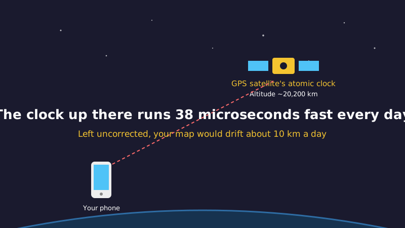
The blue dot on the map you checked this morning sits on top of a clock that engineers deliberately mis-set, on purpose, 20,000 km above your head.
Leave that clock alone and the dot would wander by roughly 10 km a day. You’d arrive at your station and the map would insist you were in the next town over. The culprit isn’t a weak signal or a broken satellite. It’s the plain mechanics of relativity, the theory Einstein wrote down over a century ago, still quietly at work today.
Finding your location is really a contest between clocks
What your car’s navigation system or your phone’s map app does is, at its core, surprisingly simple. GPS satellites orbiting overhead each broadcast a signal carrying the exact time it was sent. Your receiver measures how long signals from several satellites take to arrive, multiplies that delay by the speed of radio waves, and gets the distance to each satellite. Once it has a few of those distances, your location falls out as the point where they all intersect.
The US Space Force runs the GPS constellation today (the Air Force handled it before Space Force stood up in 2019). The satellites orbit at an altitude of about 20,200 km, with roughly 32 operating at any given time, though a minimum of 24 is enough to cover the entire globe. According to NIST, this method pins down your position to within 10 meters.
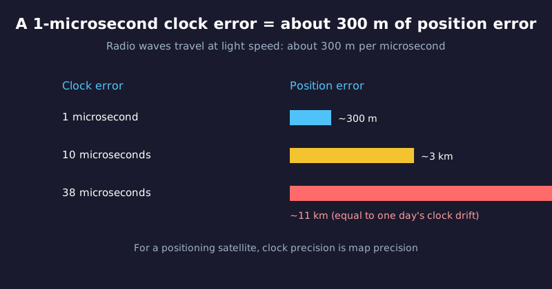
Here’s where the speed of radio waves starts to matter. Radio travels at the speed of light, covering about 300 meters in a single microsecond, one-millionth of a second.
Which means a satellite clock that’s off by just one microsecond throws your position off by roughly 300 meters.
That’s why every satellite carries an atomic clock, built from rubidium or cesium atoms for extreme precision, synced to the master clock kept by the US Naval Observatory. For a positioning system, clock accuracy translates directly into map accuracy. The catch is that these clocks inevitably drift out of step with clocks on the ground.
Clocks in orbit drift for two separate reasons
I’ll admit it: for a long time I assumed satellites simply ran slow because they’re moving fast. The real picture involves two effects pulling in opposite directions at once.
The first comes from special relativity: the faster something moves, the slower its clock ticks. GPS satellites race around Earth at roughly 4 km per second, about 14,000 km/h, so their clocks fall behind ground clocks. Richard Pogge, an astronomer at Ohio State University, puts this effect at about 7 microseconds a day.
The second comes from general relativity: the stronger the gravity, the slower time passes. The ground sits deep in Earth’s gravitational well, while a satellite 20,000 km up feels much weaker gravity. That makes the satellite’s clock run fast relative to the ground, by about 45 microseconds a day, according to the same explanation.
The directions matter here. Speed drags the clock backward; weaker gravity pushes it forward.
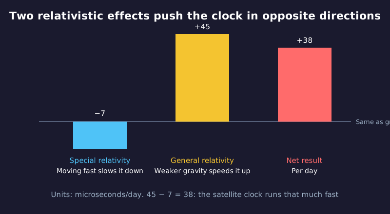
Net result: 38 microseconds fast, every single day
Add the two effects together and what do you get? Minus 7 from one, plus 45 from the other. Net it out, and a GPS satellite’s clock runs about 38 microseconds fast every day compared to the ground. Forty-five minus seven is thirty-eight: basic arithmetic, nothing fancier than that.
Thirty-eight microseconds sounds almost too small to matter. A single eye blink takes roughly 100,000 microseconds, so we’re talking about less than a 3,000th of that.
But apply the “300 meters per microsecond” rule from earlier and the picture changes fast.
That 38-microsecond drift translates into about 11 km of position error, and it compounds daily. Pogge’s explanation notes that without correction, positional error would pile up at roughly 10 km per day: 20 km after two days, 30 km after three. Leave it alone for a week and your map would be pointing at an entirely different city.
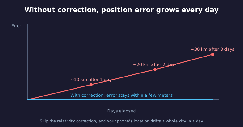
If you strapped a wristwatch onto one of these satellites, it would end up a tiny bit further into the future than an identical watch left on the ground, every single day. You’d never feel the difference in your body. But instruments track it with total precision, and left unchecked, it would quietly wreck your navigation.
Engineers slow the clocks down before launch, on purpose
So how do engineers actually fix this? This is my favorite part of the whole story, because it’s so refreshingly human.
Nobody scrambles to patch the relativistic drift after the fact. Instead, each satellite’s atomic clock is deliberately built to run slightly slow by ground standards before it ever leaves Earth. Engineers know gravity will weaken in orbit and speed the clock up, so they ship it pre-adjusted to run behind, cancelling that gain out in advance.
Once the satellite reaches orbit, the speed-up from weaker gravity balances out the built-in lag, and the clock appears to match ground time. Ground control stations then monitor the signal continuously and nudge away whatever small drift remains, day by day. According to NIST, this is how GPS atomic clocks stay locked to world standard time, continuously, for the life of the mission.
In other words, relativity isn’t a theoretical curiosity up for debate here. It’s a design spec, baked into the machining tolerances the moment the clock leaves the factory.
It’s not just a GPS problem
The United States isn’t alone in wrestling with this. Europe’s own satellite navigation system, Galileo, runs on essentially the same physics.
According to ESA, Galileo’s satellites orbit at about 23,222 km with a full constellation of 28 satellites. By using two frequencies, the system reaches real-time positioning accuracy of about 1 meter. Hitting that kind of precision requires keeping every satellite’s clock locked to ground station time, just like GPS.
Because Galileo orbits slightly higher than GPS, gravity is even weaker up there, meaning the clock speed-up effect is stronger still. The higher a navigation satellite flies, the harder it is to escape the relativistic correction. Behind the convenience of every country’s positioning system, the same physics is quietly being fought.
Einstein, somehow, became your tour guide
NASA’s records show the first GPS satellite launched in 1978, with the full 24-satellite constellation reaching operational status in 1993. The system started life as a military tool. These days, it works nonstop, in the palm of someone running late for a meeting or a tourist hunting for the right turn in an unfamiliar city.
Here’s what makes it worth pausing over. When Einstein wrote about time and gravity in 1905 and 1915, map apps weren’t even a glimmer of a concept. A theory born purely out of asking “what is time, really?” has, a century later, become the engineering that shaves 38 microseconds off a clock 20,000 km overhead.
Next time that blue dot snaps precisely into place, remember what’s underneath it. That instant of accuracy rests on an elaborate, ongoing routine: deliberately throwing a clock off every day, then correcting exactly what was thrown off. Einstein’s theory isn’t just written across the night sky. It’s quietly doing its job in the palm of your hand, every single morning.